2009 April 22 - Placing Google Maps in Blogs
{Click on any photo to view Full Size image}
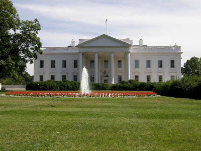
Okay I just uploaded a few images of this tall Aussie girl along with an image of an unrelated building.
I will place a Google Map of the location and address of the building after its image. The other photos are just eye candy.
Okay here is the building located in Washington, DC
View Larger Map

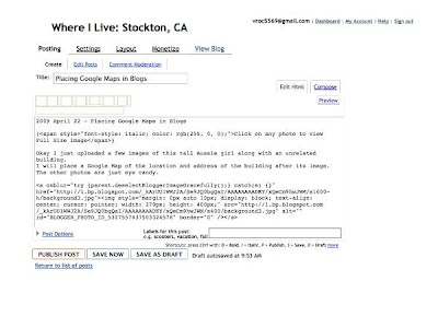
After I have loaded all of my photos. I switch from "Compose" to "Edit Html".
I then place a blank line between photos by hitting the "return key".
That way I can cut and paste the photos into the sequence that I want.
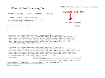
Then I triple space where I wish to embed the Google Map in the Blog.
You MUST be in "Edit Html" mode to properly embed a Google Map because the Link is a bunch of HTML code.
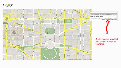
In another Window I have developed the map. Usually it is an entire Ride Route, but for this example it is just a spot location. I then "play with" the "Customize and preview the embedded map" in Google.
Once I have the map finalized I then Copy the link that is in the box "Paste HTML to embed in website". {note: While you are building your Blog the map within it will simply flash "loading". Ignore this. The map will show up when you View the Blog.}
After ALL of the images and maps are in place. I publish the Blog and view it without narrative.
When all is how I want the Blog without narrative I then Edit the Blog and write in the narrative and photo captions. Then I Publish the Blog again.
For those really familiar with Google Maps my Ride Route maps can be viewed with Street View and you can take a Virtual Ride. But some roads in Google do not have a Street View. I doubt if the one lane portion of Knoxville-Berryessa Road has a Street View. :-)
~fin
Wednesday, April 22, 2009
Tuesday, April 21, 2009
2009 April 21 - Campo Seco
{Click on any photo to view Full Size image}
Since Big Daddy [VROC #8838] has not seen his property in Campo Seco in over 20 years I thought that I would take a ride up there an shoot a few pics. {Actually the weather was just too good not to go for a ride}
Anyway I got to Liberty Road and Hwy 88 and that is where the Map starts.
If you click on the View Larger Map it will become an interactive Google Map and you can zoom in or even use Street View for a Virtual Ride.
View Larger Map
I forgot that there is no place to pull off for a photo op on Camanche Parkway. You can stop at Camanche Village but there is nothing to photograph there.
So anyway my first stop is where Camanche Parkway "T" s into Buena Vista Road. This is only a couple of miles from Stony Creek Road which we took off of Buena Vista Road to get to Pardee last Friday.
I took the right turn toward Camanche South Shore
Since I was riding my dual sport I took Campo Seco Road off of Camanche Parkway South. It is shorter but takes longer than to go to Chile Camp Road and stay on real pavement. After a few miles of first gear standing on the pegs I get back to asphalt and get to Campo Seco.
The Catholic Cemetary at Campo Seco
Another photo of the Catholic Cemetary
The Historical Marker at Campo Seco
This looks like it may have been the Campo Seco General Store at one time
Campo Seco has city street signs
The remains of the Adams Express Building
A quick ride into Valley Springs to grab a burger and a Coke. Then I head off to Hogan Reservoir.
Hogan Reservoir
Hogan Reservoir
I did not get down to the campgrounds at Hogan. I turned at Vista del Lago Road to head back to Hwy 26.
Houses and subdivisions like these line Vista del Lago Road all the way from Hwy 26 to Hogan Dam Road
More houses on the way to Hogan Dam Road
I have to stop in Lockeford which is on Hwy 88 the route to HSVROC. I promised to get my friend some Linguica.
Storefront of Lockeford Sausage
And on the last leg of my ride I stop at the strawberry patch that we went to Saturday evening. This is one of the best patches in the area. And there are probably a 100 within a 50 mile radius.
A basket of strawberries
~end
.
Subscribe to:
Posts (Atom)