Where I was born - Rohwer Relocation Center, AR
{Click on any photo to view Full Size image}
I was born in one of ten WW II Relocation Centers or Japanese-American Internment Camps. The Center that I was born in was Rohwer Relocation Center, AR on January 1, 1944.
Today was my first time visiting the site of that Camp since I left it as an infant in early 1945.
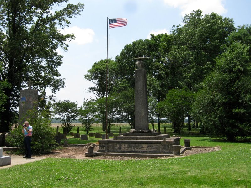
The only thing that is left is the Center Cemetery and four monuments placed in the surrounding little plot of land adjacent to the Cemetery.
An article in the Encyclopedia of Arkansas History about Rohwer
The Toyota is pointing out since I took this photo as I was leaving what is left of Rohwer.
The little grove of trees at the end of the road is the location of the Memorial.
 There is about a 1/2 mile gravel road from AR 1

 One of 24 head stones

I was talking to my mother on the phone and the following photo is a view of where the rest of the buildings stood during WW II.

There were 10,000 residents at Rohwer during WW II.


The burg of Rohwer does have a Post Office, it is not on AR 1, but on an old adjoining road that may have been the old highway.


The long ago shut down General Store adjacent to the Post Office.

Click on the "View Larger Map" for an interactive map:
View Larger Map
~end of 2009 visit
My second visit within a one year time frame.
May 11, 2010
Rohwer Relocation Center, Arkansas where I was born on January 1, 1944
Click on any photo to see it full sized
I had just visited the site of the Jerome Relocation center which is only 24 miles south of Rohwer. But Rohwer is where I was born and at that site the cemetery still remains.
This year I am riding with my friend Sherm from Coos Bay, OR. He took the photos where I am in the picture. I have him in a couple of my photos.
From Wikipedia:
In its summary on the Rohwer Relocation Center Cemetery, the National Park Service indicates that the cemetery's condition is threatened due to deterioration of the grave markers and monuments, but that ownership of the site is unclear.[1] Deterioration is visible in photographs of the site. Deterioration is discussed in a report from the National Park Service to the President.[3]
A tank-shaped memorial, made of reinforced concrete, guards the cemetery, commemorating Japanese Americans who fought for the United States at Anzio and elsewhere in Italy and France during World War II. Thirty-one who came from Rohwer died in action, and their names are inscribed on the memorial, as well as a later memorial raised nearby.[3]
The cemetery is located 0.5 miles (0.8 km) west of State Route 1, approximately 12 miles (19.3 km) northeast of McGehee, Arkansas. Signs identify the graded road which goes from the highway to the cemetery, where there is room to park automobiles.
Here is the sign along Arkansas Hwy 1. But there is nothing at all there save a house or two along side the road.

Off on a side road there is the Rohwer Post Office in a pre fab building. Rohwer's zip code of 71666 is also shared with parts of McGehee.

Here I am getting ready to go inside the Post Office.

The Post Mistress is sorting out the mail in her office.

Here is the 71 year old Post Mistress who has held this job for about 35 years and lives just up the road a few miles.

These are some photos of the inside of the Post Office


Next door to the Post Office is Donley's General Store which closed its doors over 20 years ago.

Back to Arkansas Hwy 1 and about a quarter mile north you turn west onto this gravel road that leads to what remains of the Rohwer Relocation Center, its cemetery.
 The clump of trees at the end of the road is the cemetery
Here are the head stones placed here from 1942 to late 1944.

Besides the cemetery there are two old monuments that were erected before the end of WW II and two fairly recent additional monuments.




I telephone mom to tell her that I am at Rohwer. Since the cemetery was at the south east corner of the Camp the land behind me was where the rest of the Camp was located.

Map of Rohwer Relocation Center

Article in the Encyclopedia of Arkansas History in Culture
Click below and read the On Line Book in a new window:
| Confinement and Ethnicity: An Overview of World War IIJapanese American Relocation Sites by J. Burton, M. Farrell, F. Lord, and R. Lord | |
~end .
.


